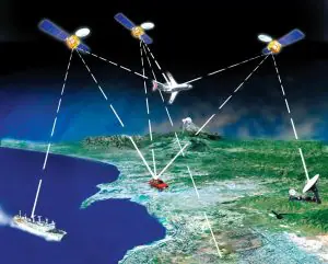
What is GPS? The GPS is a satellite-based navigation system made up of three parts: satellites (at least 24 satellites), ground stations, and receivers.
- Satellites are situated on or near the Earth’s surface and orbit the Earth. They send signals to your GPS devices which read and interpret and signal and provide the information you need.
- A ground station is a terrestrial radio station designed for extraplanetary telecommunication with spacecraft (constituting part of the ground segment of the spacecraft system) or reception of radio waves from astronomical radio sources.
- A receiver, such as the one in your phone or your car, is always looking for a signal from these satellites and calculates their distance from some of them.
With no membership fees or setup expenses, GPS works in every weather condition, anywhere in the globe, 24 hours a day. The satellites were initially launched into orbit for military purposes, but in the 1980s, they were made accessible for civilian usage.
The GPS space segment now consists of 31 satellites circling the globe around 12,000 miles above us. These satellites are continuously in motion, completing two orbits in under 24 hours. They can reach speeds of up to 7,000 miles per hour. Small rocket boosters ensure that each satellite stays on course.
How Does GPS Work?
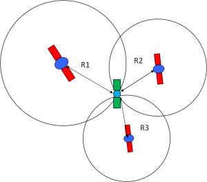
GPS satellites circle the Earth twice a day in a precise orbit. Each satellite broadcasts a unique signal and orbital characteristics, which GPS systems can decode and calculate the satellite’s precise location. This information, together with trilateration, is used by GPS receivers to compute a user’s actual position.
The GPS receiver calculates the distance between each satellite by the time it takes to receive a broadcast signal. The receiver can calculate a user’s position and show it electronically using distance measurements from a couple more satellites, allowing you to measure your running route, map a golf course, find your way home, or embark on an adventure anywhere.
A GPS receiver must be latched onto the signal of at least three satellites to determine your 2-D location (latitude and longitude) and track movement. The receiver can identify your 3-D position if four or more satellites are visible (latitude, longitude, and altitude). A GPS receiver will often track eight or more satellites, depending on the time of day and where you are on the planet.
What Is a GPS Tracking Device?
A GPS tracking device is a small gadget that can be used to track and monitor vehicles, people, and pets’ locations. Car tracking systems are the most popular use for these devices.
There are a few important differences between tracking devices and in-car navigation systems. GPS navigation systems display a driver’s location on a digital map and then offer driving directions to a specific destination. GPS trackers, on the other hand, employ GPS technology to keep track of a vehicle’s present location and journey history.
How Does GPS Tracker Work?
GPS Tracker
GPS trackers use a network of satellites to establish their locations. The tracker determines latitude, longitude, elevation, and time through trilateration, which employs the positions of three or more satellites from the Global Navigation Satellite System (GNSS) network and their distance from them.
OBD Tracker
It’s easy to figure out how to use a GPS tracker. The onboard diagnostics (OBD-II) connector, a cigarette lighter, an accessory socket, or an internal battery will often power the tracker in the car. The data it collects is then sent to software that allows the user to combine and evaluate the information.
What is the relationship between GPS trackers and the software? Some are active trackers, which can offer users a real-time glimpse of their worldwide location. A managed service may be built around this sort of tracker.
GPS Tracking System
Passive trackers are different from real-time GPS trackers, they just store GPS data to be accessed later so they are frequently less expensive than active real-time trackers.
How Accurate Is GPS?
GPS receivers are exceptionally precise thanks to their parallel multi-channel construction. When our receivers are initially switched on, they quickly latch onto satellites. They retain a tracking lock in deep forest cover or metropolitan areas with towering structures.
Most SEEWORLD GPS trackers are typically accurate to within 10 meters. However, you should know that the accuracy of GPS receivers can be influenced by atmospheric variables and other causes of inaccuracy.
A differential GPS (DGPS), which corrects GPS distances to within an average of 1 to 3 meters, can also improve accuracy. The most prevalent DGPS correction service is provided by the US Coast Guard, which consists of a network of towers that receive GPS signals and deliver a corrected signal through beacon transmitters.
In addition to their GPS, users will need a differential beacon receiver and beacon antenna to receive the corrected signal.
What Are GPS Systems Used For?
Find Location
One of the most common uses of GPS is to track a person’s location in real-time and receive instant notifications. It’s an excellent tool for adventurers, car companies, and fleet management. As Global Positioning System assists them in arriving at their destination safely and on time by providing the best route available.
Disaster Monitoring and Recovery
In the event of a worldwide calamity, GPS saves lives and guarantees that sufferers recover quickly. The use of location data combined with automation reduces the time it takes for emergency services and supplies to arrive. In fact, it works in any weather, at any time, and in any location.
Meteorologists utilize this cutting-edge technology to forecast storms and floods. They analyze data transfers via the atmosphere using GPS to determine water vapor concentration.
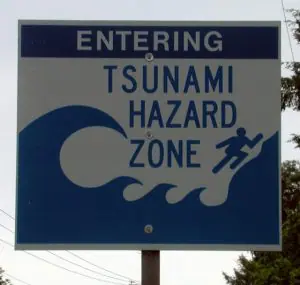
GPS can help provide early warning of tsunamis. Credit: mnlamberson.

GPS is used to monitor volcanoes. Credit: Earth Uncut Productions Ltd.
Emergency Assistance
There are over 2,000 individuals go lost in the woods every year. So, whether you’re lost in a remote area or suffer an accident, you can use features like real-time tracking, route history, geofence zones, and notifications on your smartphone to contact emergency services. The added benefit is that it works even if you fail to tell the emergency personnel your position.
Car Theft Prevention
GPS may be an effective anti-theft tool. You can monitor and locate your car by placing it in your vehicle.
Surveying
Some surveying companies employ GPS in surveying and mapping operations. Surveyors can use the GPS program to place it at a specific location and establish a reference marker. Furthermore, the data is transmitted to the surveying app and then immediately transferred into a thorough chart.
Find Lost Pets
Are you a huge pet lover? If this is the case, attach a tiny GPS tracking device to your pet and you can use it to locate them swiftly if your pet goes missing.
Keep an Eye on the Elderly
Another significant advantage of GPS technology is that it may be used to keep a watch on elderly or handicapped family members. Seniors can use a little button on these gadgets to make emergency calls for quick medical assistance. When your loved one presses the SOS button, you will receive a notification.
What Is the GPS Signal?
GPS signals include ranging signals, measuring the distance to the satellite, and navigation messages.
GPS signals. Credit: NASA
The signals travel along the line of sight, which means they can pass through clouds, glass, and plastic but not through most solid things like buildings and mountains. Modern receivers, on the other hand, are more sensitive and can typically track through homes.
There are three sorts of information in a GPS signal:
A pseudorandom code is an I.D. code that determines which satellite is delivering data. On the satellite tab of your device, you can see which satellites are sending you signals.
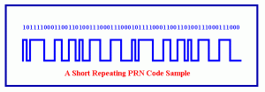
Pseudorandom Code. Credit: Uregina.ca
Ephemeris data is required to establish a satellite’s position and provides vital information such as the satellite’s health, current date, and time.
Almanac data informs the GPS receiver where each GPS satellite should be at any given moment of the day, as well as the orbital information for that satellite and all others in the system.
What Information Can A GPS Device Get?
The GPS unit can get additional data, such as:
- Speed
- Bearing
- Track
- Distance traveled
- Time of sunrise and sunset
Other GPS System
There are several systems around the globe that are comparable to GPS and are all designated as the Global Navigation Satellite System (GNSS). GLONASS is a Russian satellite constellation system. Galileo is being developed by the European Space Agency, whereas BeiDou is being developed by China.
Fact About the GPS System
Here are a few more fascinating facts regarding GPS satellites:
- NAVSTAR is the official US Department of Defense term for GPS.
- In 1978, the first GPS satellite was launched.
- In 1994, a full constellation of 24 satellites was completed.
- Each satellite is designed to endure around ten years. Replacements are produced and sent into orbit regularly.
- With the solar panels extended, a GPS satellite weighs around 2,000 pounds and measures about 17 feet across.
- Solar energy powers GPS satellites, but they also carry backup batteries in case of a solar eclipse.
- The transmitter’s output power is 50 watts or less.